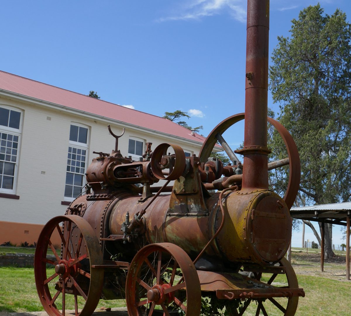
Hillgrove was initially known as “Eleanora Township”, was established in 1884 and grew rapidly during the 1880s and 1890s due to expanded mining activities after rail transport from Sydney to Armidale enabled heavy machinery to be brought to the district.
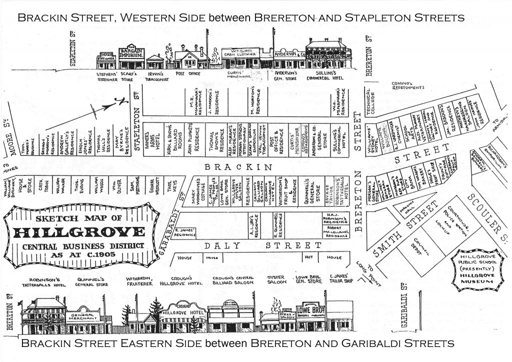
At its peak in about 1898, the population numbered around 3,000 and Hillgrove boasted six hotels, four churches, two schools, several banks, a School of Arts, hospital, stock exchange, court house, police station and cordial factory. By the 1920s, most of the village’s buildings were being dismantled and relocated to Armidale and other centres. The result is a fascinating “town” with lots of signs indicating where buildings once stood and lots of empty blocks of land with scattered, rusting relics which hint at a more prosperous time.
Hillgrove Rural Life and Industry Museum
Hillgrove, initially known as Eleanora Township, was established in 1884 and grew rapidly during the 1880s and 1890s due to expanded mining activities after rail transport from Sydney to Armidale enabled heavy machinery to be brought to the district. At its peak in about 1898, the population numbered around 3,000 and Hillgrove boasted six hotels, four churches, two schools, several banks, a School of Arts, a hospital, a stock exchange, a courthouse, a police station and a cordial factory.
By the 1920s, most of the village’s buildings were being dismantled and relocated to Armidale and other centres. The result is a fascinating “town” with lots of signs indicating where buildings once stood and lots of empty blocks of land with scattered, rusting relics that hint at a more prosperous time.
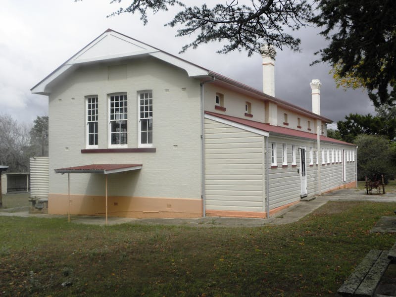
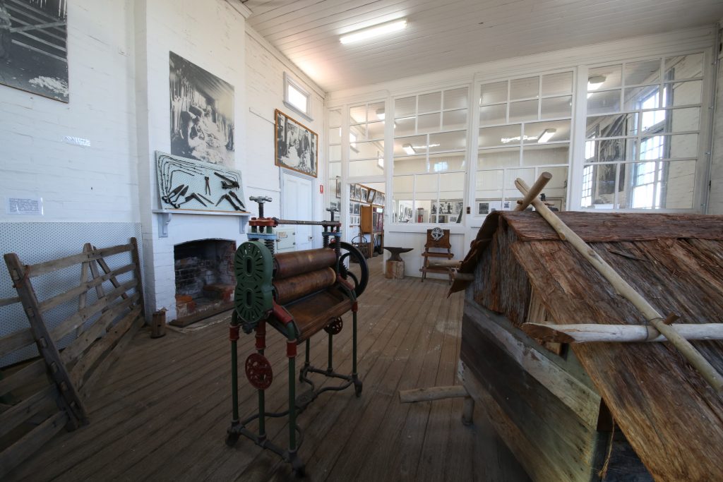
Hillgrove Rural Life and Industry Museum, located in the former Hillgrove Public School built in 1896, showcases the history of the town, its community and the mining industry in the region. Objects in the museum provide some insight into the lives of the nearly 3500 people who lived and worked in Hillgrove between during the 1880s to 1920s.
Wind along the picturesque Waterfall Way and through World Heritage listed national parks to the most spectacular gorges, waterfalls, crystal clear streams and views in the region.
Tourist Drive 17 is named the Best of New England for good reason. From Armidale, the route takes you along the picturesque Waterfall Way (itself rated second only to the Great Ocean Road in Australia’s top drives) and through World Heritage-listed national parks to the most spectacular gorges, waterfalls, crystal clear streams and views in the region.
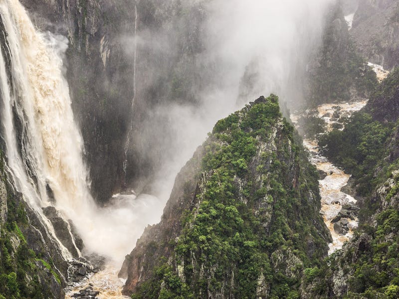
Highlights of this trip include Gara Gorge and Wollomombi Falls in the Oxley Wild Rivers National Park, Point Lookout in the New England National Park, massive boulders in the Cathedral Rock National Park and Ebor Falls.
You also pass through the once thriving mining towns of Hillgrove and Metz, visit a trout hatchery and stop by the calm waters of Malpas Dam.
If you like to combine an easy walk with a spectacular view then it’s time to pack the car and head to Gara Gorge lookout, accessed along Threlfall walking track. You’ll be rewarded with scenic views down the rugged gorge.
From the lookout, you’ll see gum-lined valleys and steep ravines that continue to the coast. Look for brush-tailed rock wallabies sunning themselves on the outlying stone as you breathe in clean, crisp mountain air. Bring your binoculars for birdwatching as peregrine falcons and wedge-tailed eagles can sometimes be seen in the skies above.
After all that fresh air and scenery, you’ll be ready for lunch, so head back to either Threlfall picnic area or the popular Blue Hole picnic area for a bush picnic or barbecue.
Pull up at this tranquil bush setting and you’ll immediately know you’ve arrived somewhere special. A little off the beaten track, Long Point campground and picnic area is a great base for exploring the high country of New England without the crowds.
As you enter the idyllic forest clearing, you may see eastern grey kangaroos relaxing in the shade of the apple box and blackbutt. While waiting for the billy to boil, you’re likely to catch the aroma of the lemon scented tea tree or native mint that grows nearby. An ideal spot for birdwatching, look for the crimson rosellas and vibrant king parrots in surrounding trees. Lyrebirds are known to forage for snacks in these parts.
After a relaxing picnic lunch, if you’re ready for some walking, there’s a choice of tracks ranging from a relaxing stroll to a challenging adventure.
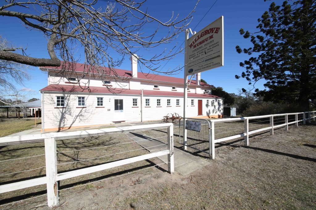
The Hillgrove Museum is situated in the old Hillgrove School (1897) on Scouler Street and it contains a collection of photographs and memorabilia designed to give the visitor “a unique insight into everyday life in old Hillgrove”. It is open Friday – Monday and public holidays from 10.00 a.m.
Hillgrove Museum Exterior
A pleasant, and informative, day’s activity is to start at Metz Gorge lookout. Travel northwards on Chinamans Gully Road to Bakers Creek Falls and tour Hillgrove, including the Museum (Friday to Monday). Then drive to the scenic Long Point Picnic Area – ideal for a picnic lunch! The day can be capped off with a picturesque bush walk.
Long Point in the Oxley Wild Rivers National Park is easily accessed from Hillgrove and promises absolute peace and serenity! Turn left from Brackin Street onto Brereton-Long Point Road, a gravel road which runs along a narrow ridge for 20 km to Long Point. This follows a Tablelands remnant ridge between the Chandler River and Bakers Creek Gorge and leads to the Oxley Wild Rivers National Park. About 1.6 km from the Park entrance, the turnoff to the recreation area on the right can easily be missed. On entering the idyllic forest clearing, eastern grey kangaroos may be seen relaxing in the shade of the apple box and blackbutt. The aroma of the lemon scented tea tree or native mint that grows nearby may be in the air. An ideal spot for birdwatching, look for the crimson rosellas and vibrant king parrots in surrounding trees. Lyrebirds are known to forage for snacks in these parts. The walking tracks and lookout platforms of Long Point offer breathtaking views over the valleys of the Great Escarpment and the upper reaches of the Macleay River.
Bakers Creek Falls are clearly signposted both on the road from Hillgrove back to Grafton Road or from Grafton Road. There is a picnic area and lookout which allows visitors to see both the falls and the gorge created by Bakers Creek. The falls are quite spectacular after rainfall and limestone, as well as sand-stone and granite are hidden among the trees and bushes of the valley. It’s the perfect little stop off along the Waterfall Way!
On the other side of the gorge, is the historic mining village of Metz. It was originally known as Sunshine and sometimes known as West Hillgrove.It came into existence in 1889 when gold mining spread across Baker’s Creek Gorge. In 1892 it became known as ‘Metz’ and by 1898 it had a population of 750 which was serviced by a post office (1890), two schools, three churches, several shops, a School of Arts, two hotels, a Masonic lodge, a brass band and cricket and football clubs. The town was short lived. By 1904 the population was in decline and the closure of the hotel, post office and school had closed by the late 1920s. Today little of the town is left and what does remain is on private property. The main interest lies in the views from the Metz Lookout where the remains of the old Bakers Creek Mine can be seen at the bottom of the gorge. It lies 490 m below the gorge wall and the mine shaft was sunk a further 610 m below the surface. A rope-hauled tramway operated by a steam-powered winding engine pulled the trams up and down the precipitous incline.